Flood risk management
Floodplain development Studies and plans Climate change LeveesFloodplain Management Committee Property development
Managing flood risk
Tweed Shire Council is responsible for managing flood risk in the Tweed.
Council is responsible for:
- developing and managing flood-prone land
- providing flood maps
- reducing damage from floods
- maintaining our flood infrastructure (levees, pump stations, flood gates)
Council's flood risk management policy(PDF, 218KB) is guided by the NSW Government's floodplain development manual.
Floodplain development
Floodplain refers to all flood prone areas in the Tweed.
Land development in flood prone areas
Standards for land development in flood prone areas are outlined in Council's Development Control Plan(PDF, 646KB). To minimise flooding impacts on the community all floodplain development must met these standards.
Floor levels
All habitable development must have a floor level above the 'flood planning level'. This is based on a 1% annual exceedance probability flood (AEP) plus 0.5 metre freeboard.
Flood liable land
Council defines land as flood liable if it’s affected by the probable maximum flood (PMF), which is the largest flood that could conceivably occur at a particular location.
Flood management planning instruments
A planning instrument is a document adopted under planning legislation by state, territory or local government. Planning instruments manage the use and development of land:
Flood related policies
Council policies that address flood planning and development:
Studies and plans
Tweed Valley Flood Study Update and Expansion 2024
This flood study is a comprehensive technical investigation of flood behaviour within the Tweed Valley catchment. The flood study uses sophisticated computer models to simulate flooding behaviour and incorporates the 2017 and 2002 floods, as well as others.
It is the first Tweed flood study to investigate flooding upstream of Murwillumbah and follows current hydrology industry standards.
- Tweed Valley Flood Study Update and Expansion(PDF, 22MB)
- Appendix A - Glossary(PDF, 74KB)
- Appendix B - 2017 hydrologic/hydraulic calibration locations(PDF, 437KB)
- Appendix C - 2017 hydraulic calibration locations(PDF, 338KB)
- Appendix D - 2017 flood maps(PDF, 5MB)
- Appendix E - 2022 hydrologic/hydraulic calibration locations(PDF, 476KB)
- Appendix F - 2022 hydraulic calibration locations(PDF, 541KB)
- Appendix G - 2022 flood maps(PDF, 5MB)
- Appendix H - 2020 hydrologic/hydraulic calibration locations(PDF, 417KB)
- Appendix I - 2020 hydraulic calibration locations(PDF, 455KB)
- Appendix J - 2020 flood maps(PDF, 6MB)
- Appendix K - 1989 hydrologic/hydraulic calibration locations(PDF, 356KB)
- Appendix L - 1989 hydraulic calibration locations(PDF, 272KB)
- Appendix M - 1989 flood maps(PDF, 5MB)
- Appendix N - At-site IFD comparisons(PDF, 291KB)
- Appendix O - FFA comparison(PDF, 254KB)
- Appendix P - Mapping(PDF, 49MB)
- Appendix Q - Hydraulic and hazard classification(PDF, 32MB)
- Appendix R - Climate change maps(PDF, 42MB)
- Appendix S - Flood emergency response classifications for communities maps(PDF, 7MB)
South Murwillumbah Floodplain Risk Management Study and Plan (2019)
Tweed-Byron Coastal Creeks Flood Study (2009)
A study into the flood behaviour of four coastal creeks: Cudgen, Cudgera, Mooball and Marshalls Creeks.
A joint study between Tweed and Byron Shire Councils (reflecting the cross-boundary flooding between Mooball and Marshall Creek).
The study area includes South Kingscliff, Cabarita - Bogangar, Hastings Point, Pottsville, Burringbar, Mooball, Crabbes Creeks, Wooyung, South Golden Beach, Billinudgel, New Brighton and Ocean Shores.
The study provided model scenarios for possible future changes in land use (e.g. agricultural change from sugar cane production) and potential impacts of climate change (sea level rise and increased rainfall intensity).
Coastal Creeks Flood Study(PDF, 10MB)
Coastal Creeks Flood Study flood maps addendum(PDF, 14MB)
Climate change and rising sea levels
In 2008 the NSW Government issued guidelines for councils to include climate change variables into flood studies.
Since then all our flood studies have included climate change modelling that considers:
- a sea level rise of 0.91 m
- an increase in rainfall intensity of 10%
Climate impact maps
Maps of climate change scenarios are available in our flood studies above. In 2010 Council adopted these climate change maps as appendices to our Development Control Plan.
The maps are applied as design flood levels for large scale greenfield residential subdivisions, such as Cobaki, Kings Forest and West Kingscliff.
Flood infrastructure
 (PDF, 3MB)
Council carries out regular testing and maintenance on our levees, flood gates and pump stations. While it’s reassuring to have these in place, the risk of flood remains.
Levees
Levees are built to provide protection from flooding. Levees are used to contain, control or divert the flow of water. However, no levee is flood-proof.
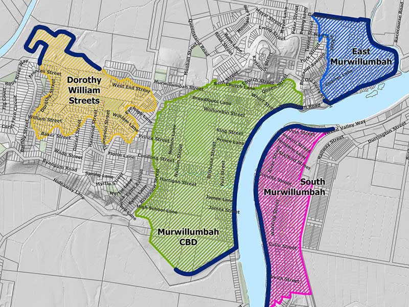
Since the 1950s Council has operated a series of flood levees throughout the Tweed:
- Murwillumbah CBD levee
- East Murwillumbah levee
- Dorothy and William Streets levee
- Tweed Heads South levee
- South Murwillumbah levee (minor)
- various rural levees
(around 40 kilometres in total)
Do you live behind a levee?
Know your risk if you live behind a levee. There may be little warning when a levee is about to overtop and it could lead to very fast flooding.
Find out:
- where levees are located (see levee map above)
- the height of floodwater the levees are designed for
Take action:
- have an emergency action plan
- know your evacuation route and when you need to evacuate
- listen for warnings (radio, TV and internet)
Levee myths factsheet (SES)
Video: When the Murwillumbah levee breaks (2018)
This video shows a 500-year flood in Murwillumbah’s central business district.
When the Murwillumbah levee overtops, the CBD will be under 4 metres of water in less than 3 hours.
(There’s a 0.2 per cent chance of the simulated 500-year average recurrence flood happening in any year.)
Video: Levee protection restored for South Murwillumbah (2020)
The video shows repairs to South Murwillumbah riverbank
In March 2017 floods undercut the South Murwillumbah riverbank and broke the crest of the flood levee. Repairs were completed in February 2020, using more than 25,000 tonnes of rock.
Council received $3.75 million from the Australian Government’s Natural Disaster Relief and Recovery Arrangements.
Floodgates
Council maintains a network of around 350 sets of floodgates. These are generally ‘flap gates’ that allow water to flow in one direction only. These stop floodwater backfilling areas behind levees and allow drainage once flood levels drop.
Flood pumping stations
There are two Council operated flood pumping stations, located in the Murwillumbah CBD. They pump water away that builds up behind the levees.
Pumping stations do not remove the flood risk completely - flooding of roadways and private property may still occur.
Council's Floodplain Management Committee
The Tweed Floodplain Management Committee provides a forum to discuss technical, social, economic, environmental and cultural issues associated with floodplain management.
The Committee includes representatives from Council, State Emergency Service, NSW State Government and the local community.
For terms of reference, agendas and minutes see Council committees.
Property development
Contact Council's Flooding and Stormwater Engineer on 02 6670 2400 if you have questions about flood-related property development.