Tweed flood study to be expanded
07 April 2021
Review will help prepare for and manage future flooding
Council has started work updating and expanding the Tweed Valley Flood Study.
The study will help define flooding behaviour under current and future climate conditions and become the basis of flood planning in the Tweed.
As part of the study, residents are being asked to share their personal experiences and knowledge to help better understand past flood events.
In 2009, there was a flood study of the Tweed River and its major tributaries, from Byangum upstream of Murwillumbah to the river mouth at Tweed Heads. The study area included Murwillumbah, Condong, Tumbulgum, Chinderah, Kingscliff, Fingal Head, Banora Point and Tweed Heads.
Manager Roads and Stormwater Danny Rose said flooding was not confined to one part of the Tweed and Council wanted to better understand flooding in the upper parts of the valley, including the villages of Tyalgum, Chillingham, Uki and the surrounding rural areas.
“A flood study is essentially a technical investigation of the flood behaviour for a region. It includes computer models to simulate historical events, which help to predict future flooding,” Mr Rose said.
“It’s crucial that we hear from as many residents as possible. Provide as much information as you can and include any photos or videos to help us understand your experiences better.
“Recent advances in the hydrology field and new flood records from March 2017 provide a good opportunity to improve our knowledge of flood behaviour in the valley,” he said.
Mayor of Tweed Chris Cherry said she hoped residents would contribute to the study because of the Tweed Valley’s long history of flooding.
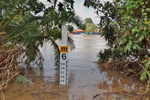
“We have just marked the fourth anniversary of the March 2017 flood caused by ex-Tropical Cyclone Debbie, so we know the devastating impact that widespread flooding can have on our community," she said.
“We will flood again but we can better prepare for the next one, and part of the preparation is the community and Council working together to develop this new study and subsequent flood risk management plans.”
The Tweed Valley Flood Study survey is now open and current and past residents of the Tweed are encouraged to take part by Sunday 16 May 2021.
Visit https://www.yoursaytweed.com.au/flood-study to complete the survey and for more information about the project.
Residents can also collect a paper version of the survey at Council’s customer service counters at the Murwillumbah or Tweed Heads Administration Offices.
The Tweed Valley is approximately 1100 km2 and incorporates a range of landscapes including steep valleys, floodplains and coastal estuaries. This variation in landscapes creates three defined types of flooding:
- riverine flooding is caused when the flow of water bursts the banks of creeks or rivers
- storm surge flooding is an abnormal rise in sea water level due to a storm, and
- overland stormwater flooding is generated by rainfall running off towards the drainage or creek system.
Funded under the Natural Disaster Resilience Program, which is supported by the NSW and Commonwealth governments, Council has engaged flood specialists WMAwater to update and expand the Tweed Valley Flood Study.
Downloads
Photo 1(JPG, 252KB)
Caption: In March 2017 ex-Tropical Cyclone Debbie brought widespread flooding to the Tweed. A flood level marker at Murwillumbah.